
FOITHEAR - SHELVING SLOPE - FOYERS
For some time now, I have been more and more disenchanted by the Dinosaur walks!
By that I mean something quite different from what you think I mean.
Please stick with this and you might see our walks in a slightly different light in the future.
Please stick with this and you might see our walks in a slightly different light in the future.
Max Weber called disenchantment a distinctive injury of modernity. What he meant was that the modern age had led to us losing our enchantment with the natural world. This was a symptom of the rise of Rationalism and had led, he thought, to a widespread reduction in wonderment. That reduction in wonder at the natural environment has since been hastened by the march of technology. More insidiously, it has been hastened by the death of language, or at least of the people who used precise words to describe the landscape within which they lived and died. The language is still there, it is just not used.
Robert Macfarlane notes that language is fundamental to the possibility of re-wonderment (at the natural environment), for language does not just register experience, it produces it.
You need to believe that everything you see cannot be quantified or qualified by measurement. There must be room for the magical. Anyone who has seen a sunset can find out why it is like it is, but that doesn't take away from the beauty and magic of it as it happens.
What I am getting at here, is that we have, all of us, become detached from our environment, through time and circumstance, but also through our lack of understanding of the language used to describe the landscapes through which we have been walking for ten years and more. We no longer wonder at it; we have become disenchanted.
I am going to try and recover some of that wonder by looking again at our walk at Foyers.
First of all, what does Foyers mean? Where does the name come from? It is given in a number of sources as Foithear, which is Gaelic for shelving slope. That is, the land takes the form of a number of shelves connected by much steeper slopes. You can see the steepness of these slopes at the Falls. In effect, the Gaelic speaking inhabitants were playing Catch Phrase - say what you see. The same description is applied to Dunottar Castle (Dun Foithear) near Stonehaven.
So, where we were walking has a history and a name that means something particular. There was a specific and deliberate attempt to apply language to describe what you could see. These descriptions are important because they pre-date readily accessible paper maps. They were, essentially, maps of the mind for people who were intimate with the landscape they lived in.
As an example quoted by Robert Macfarlane, Angus MacMillan from Lewis recalls being sent by his father across seven miles of moorland to find a lost sheep. He was told that the sheep was just behind the Grey Ledge by the Raven's Hollow above the Mill Loch.
The ability to describe and understand this language of place was vital to people and critical to their survival. It was a language that had to be precise. For instance, there are over 2000 words recorded as being used to describe moorland features in Lewis.
Anyway, we gathered together in the car park at The Camerons. The tearoom is part of Glenlia Farm. In turn Glenlia is an Anglicisation of the Gaelic Glen Liath. The Grey Glen. This is thought by some to relate to the colour of the bark of the many birch trees that line the sides of the Glen or perhaps the colour of waving grass in some lights. Gaelic is a very descriptive language that will have meant for the observer to see something particular about the greyness of Glen Liath.

We see surprisingly little wildlife on our walks. That may be to do with the retreat of nature from humanity or the fact that we make too much noise when walking. I don't just mean the fact that the walks have become a social catch up opportunity, but also that we have lost the ability to walk silently through the forest and so we disturb more than we see.

Certainly we would have seen more on this walk in the past. The short section at the start through the trees and uphill a bit takes us near to Creag Nam Broc and Sgorr na h-Iolaire.
The Rock of the Badger and the Peak of the Eagle. We saw neither, but they must have been common enough here in the past to have given their names to the landscape in such a way that people would know exactly where you were referring to.
We soon came to the little reservoir, which sits above a Scottish Water plant building that we did not visit or see.
The reservoir itself is remarkable, particularly on a still day like the one when we were there. Water holds a fascination for most cultures and the UK has huge numbers of words to describe the variety of water you might come across.
In Gaelic, this might be a botunn - a deep pool or, more likely, a lochan. Interestingly, at least to me, Gaelic distinguishes between lochans or pools like this and pools in rivers. A glumag is a deep pool in a river, but a linne is an even deeper pool in a river. When I was a boy we were not allowed to go on our own to swim or fish in a deep pool in the River Nevis called the Lingie, which must come from the Gaelic linne. Only now do I realise why it had that name and what it meant. In Kent they might call this a hassock. In west Cornwall it would be a lidden, but in the Cotswolds it would have been a plash. In southern Scotland a puil and in northern England a tarn.
So many different words that would have been clear to the people using that language of place and all a bit more exciting and descriptive than a reservoir or pond.

Jimmy went out onto some boggy ground beside the reservoir to take a photo. As you might expect if you have persevered with this blog, there are all sorts of words to describe boggy or marshy ground. If there was a slender stream there it might be a caochan in Gaelic. That is a slender stream obscured by vegetation so that it is virtually hidden. The word is thought to have come from caeich meaning blind, that is the stream is so overgrown that it cannot see out of its own bed. How descriptive is that and all from one word.
Other words that might apply to the ground Jimmy is on are mign (Welsh for bog or mire), gads (Kentish for the rushes and sedges that he is standing on), in Gaelic these same sedges might be starr, gersick (Cornish for a reed swamp).
There were alder trees near to where Jimmy is standing. Alder were peasant trees in the Gaelic hierarchy of trees. Chieftain trees were the likes of oak and there were also shrub trees such as blackthorn, which we saw a lot of elsewhere on the walk and herb trees like heather, which we certainly saw plenty of. Alder used to be used for making shields.

But, enough of the soft stuff. We left behind the reservoir and came down hill into Foyers.
The Foyers area was inhabited in pre-historic times as shown by the vitrified fort on Dun Dearduil (hill of Deirdre) at Inverfarigaig. The area would have been part of the ancient Pictish Kingdom based around Inverness..
The Gaelic name for the falls is Eas na Smudh - Waterfall of Smoke. This a reference to the spray emanating from the Falls. They are over a hundred feet high. However, the Gaelic name is a little less apt now as the flow over the falls was reduced as a result of the diversion of water for the British Aluminium works at Foyers and the subsequent pumped storage hydro scheme.
You can just see the easaraich, which is the Gaelic name given to the boiling of a pool where the cascade falls. In heavy rain, the river would flow brown and Gaelic has a name for that - ruadh-bhuinne. The noise of waterfalls is of some importance in Gaelic superstition. So taghairm is a word used to describe the noise and echoes of a waterfall, but also a type of divination. The Gaelic dictionary Am Faclair Beag states...
“The divination by the taghairm was once a noted superstition among the Gael and in the northern parts of the Lowlands of Scotland. When any important question concerning futurity arose and of which a solution was, by all means, desirable, some shrewder person than his neighbours was pitched upon to perform the part of a prophet. This person was wrapped in the warm smoking hide of a newly-slain ox or cow, commonly an ox, and laid at full length in the wildest recess of some lonely watefall. The question was then put to him and the oracle was left in solitude to consider it. Here he lay for some hours with his cloak of knowledge around him and over his head, no doubt, to see the better into futurity; deafened by the incessant roaring of the torrent; every sense assailed; his body steaming; his fancy in a ferment; and whatever notion had found its way into his mind from so many sources of prophecy, it was firmly believed to have been communicated by invisible beings who were supposed to haunt such solitudes”.

St. Columba, passed through Foyers on his way to convert King Brude. It was at this time that the first sighting of the Loch Ness monster is recorded.
Foyers was ruled over by a succession of Lairds. The Mormaers of Moray had rights in the 11th and 12th Centuries. After them came the Grants who had large estates in the area. They moved to Strathspey and the Frasers became dominant. They were of Norman descent and settled around Foyers in the 15th Century. The Frasers came to be linked with Foyers until the 1840s, some 400 years.
Fraser of Foyers was excluded from the Act of Parliament pardoning treasonable offences committed in the 1745 rebellion, and went into hiding for seven years after the rebellion. One of his favourite haunts was a cave, a mile to the west of the Falls of Foyers. One day, he saw a Red Coat secretly following a girl bringing food for him and, to avoid capture, he shot the soldier who was buried where he fell.
Peace eventually came to the Highlands, but with that peace, came the opening of the Highlands to tourists and among the visitors to view the magnificence of the Falls of Foyers were Doctor Johnson and James Boswell, Robert Southey, Robert Bums, Sir Walter Scott and Lord Colchester who opened a fund so that the road to the Falls could be improved.

The Gaelic name for the falls is Eas na Smudh - Waterfall of Smoke. This a reference to the spray emanating from the Falls. They are over a hundred feet high. However, the Gaelic name is a little less apt now as the flow over the falls was reduced as a result of the diversion of water for the British Aluminium works at Foyers and the subsequent pumped storage hydro scheme.
You can just see the easaraich, which is the Gaelic name given to the boiling of a pool where the cascade falls. In heavy rain, the river would flow brown and Gaelic has a name for that - ruadh-bhuinne. The noise of waterfalls is of some importance in Gaelic superstition. So taghairm is a word used to describe the noise and echoes of a waterfall, but also a type of divination. The Gaelic dictionary Am Faclair Beag states...
“The divination by the taghairm was once a noted superstition among the Gael and in the northern parts of the Lowlands of Scotland. When any important question concerning futurity arose and of which a solution was, by all means, desirable, some shrewder person than his neighbours was pitched upon to perform the part of a prophet. This person was wrapped in the warm smoking hide of a newly-slain ox or cow, commonly an ox, and laid at full length in the wildest recess of some lonely watefall. The question was then put to him and the oracle was left in solitude to consider it. Here he lay for some hours with his cloak of knowledge around him and over his head, no doubt, to see the better into futurity; deafened by the incessant roaring of the torrent; every sense assailed; his body steaming; his fancy in a ferment; and whatever notion had found its way into his mind from so many sources of prophecy, it was firmly believed to have been communicated by invisible beings who were supposed to haunt such solitudes”.
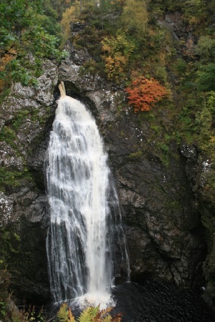
It was after a visit to the falls that Robert Adams reported in 1834 what is known as Motion Aftereffect or the waterfall illusion. In essence if you look at a waterfall ( or any other moving thing) for a period of time, look away then look back at the rocks at the side of the falls they appear to move upwards. Perhaps it was this effect that meant Sharon, Mac and Jimmy couldn't look at the waters.

The bridge photo below is taken through a stand of Hazel bushes. Hazel was an important tree because it is ideal for coppicing. That is, it can be cut down to the base and will grow back straight flexible stems that can be harvested a few years later. This can go on over a long period of time. Hazel was used to provide a constant supply of firewood, wattle for wattle and daub, building, thatching, fencing and plant supports. There is still a hazel coppicing industry today. Indeed, the practice of coppicing has given its name to nearby Boleskine. The hut of the withy-stripping = Both a’ Fhleasgainn [Boleskine]

Aluminium ingots were first produced in the Highlands at Foyers in 1895. The works closed in 1967. The British Aluminium Company bought the exclusive rights to the electrolytic method of aluminium production. There was a huge outcry, from the artistic community in particular, to the diversion of water from the Falls to provide power for aluminium production. Materials were transported to the factory through the Caledonian Canal and a light railway linked Foyers pier with the works. Ironically the factory building was used for a short time after the closure of the works to make canal narrow barges. The cottages below were built about 1896 to house workers in the Aluminium plant.

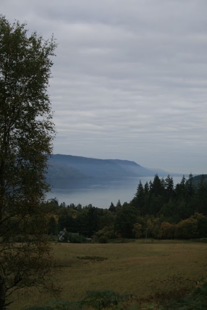
And so, to Loch Ness. The River Foyers is a major feeder of Loch Ness and there is some suggestion that the Falls, An Eas in Gaelic, gave their name to the Loch - Loch an Eas.
I have to say that I prefer the old Gaelic tale set out below.
Where Loch Ness now is, there was long ago a fine glen. A woman went one day to the well to fetch water, and she found the spring flowing so fast that she got frightened, and left her pitcher and ran for her life; she never stopped till she got to the top of a high hill; and when she was there, she turned about and saw the glen filled with water. Not a house or field was to be seen! "Aha!" said she, "Tha Loch ann a nis." (Ha Loch an a neesh). There is a lake in it now; and so the lake was called Loch Ness (neesh).
Whatever the derivation of the name, Loch Ness is pretty spectacular in a number of ways.
It contains more water than all the lakes and rivers of England and Wales combined. It also contains more water than any other Scottish loch. It is only 16 metres above sea level, which is one of the things that attracted Thomas Telford to the idea of the Caledonian Canal. It is comprised of two large and very deep basins separated by a bar of silt that is carried down the River Foyers. It is home to many species of fish including large pike, salmon, ferox trout and Arctic char.

Interestingly, the Loch has seen some water battles.
In 1749, Laurence Grant of Foyers and Boleskine, insulted the young bride of Gruer Mor (Big Gruer), Laird of Port Clair (Fort Augustus), while on a visit to Foyers. Gruer was so incensed that he gathered his clan together and set out in galleys to Foyers determined to exact revenge on Laurence Grant and his clan. The two clans met in their galleys at a bay about a mile west of Foyers and the battle of Camus Mharbh Dhaoine (Bay of the Dead Men - so called to this day) took place, in which Laurence Grant was defeated and killed after trying to escape on the other side of Loch Ness at Ruskich.
Following Cromwell's invasion of Scotland, he subdued warring clans by garrisoning troops at Inverness and Fort William. He also stationed a troop carrying warship which patrolled on Loch Ness.

Jimmy and Jacque sit by the shore of the Loch and warily watch the caitean - Gaelic for the first slight ruffling of the water after the calm. That is before it became an acker, a term used along the North Sea coast of England to describe a ripple on the water. If the monster had been there, the water might have become agitated or in the Scots dialect , jabbly.

Lunch was on a beach made up of what in Exmoor might be called dappy stones. Certainly it was a garbhlach or stony place.

In 1790, Simon became the 11th laird of Foyers, and as it turned out, the last of the Frasers of Foyers. He only had one daughter, Jane, who died before him in 1817. Jane died of a broken heart after her fiancee, Patrick Grant of Glenmoriston, who was her cousin, was killed when he fell out of a tree. Jane married another but died soon afterwards. This is her monument.

The Highland Clearances had a limited effect on the Foyers estates. The area surrounding the Fraser's mansion house was cleared to make way for one large farm, Foyers Mains, which once was a substantial and imposing building, but now lies derelict and somewhat forlorn. In 1843 Simon Fraser, the last proprietor of the Frasers' lands in Foyers had died. The estate was sold off to pay debts. Foyers Mains was run as a farm and in 1865, an Edinburgh business man, who had bought the whole estate in 1859, enlarged and improved the farm by building the farm steading.

The octagonal building set apart from the main building also dates to 1865. It is most unusual in that it was designed to be both a henhouse and a dovecote.

We walked uphill along the edge of a forestry plantation. That forest is named on the Ordnance Survey map as Camus Forest possibly after the battle of Camus Mharbh Dhaoine (Bay of the Dead Men) which must lie just to the north.


Once round Speckled Hill we came down towards the Upper Falls of Foyers. These are famous for having been sketched by Turner in 1831. Although the water is known as the River Foyers, it is also known as the River Fechlin. It is only near Foyers that the water takes its name from the village. In fact, it has its source some miles away in Glendoe Forest, far to the south and west of Whitebridge. It starts as Allt Breineag, which seems to denote something putrid or disgusting! There is also a meaning related to smelly, boggy ground that might be a reference to the source of the stream. It is joined by Allt dubh Cuil na Creige - the black stream of the corner of the hill. This water joins the River Fechlin, which rises in Loch Killin and the whole river becomes the River Foyers as it nears the village.
We crossed over the bridge into the village and onto The Camerons for tea and cakes. The bridge may have been built by General Wade as the road on either side is thought to have been the route of one of his roads, but that is not certain.


The bridge photo below is taken through a stand of Hazel bushes. Hazel was an important tree because it is ideal for coppicing. That is, it can be cut down to the base and will grow back straight flexible stems that can be harvested a few years later. This can go on over a long period of time. Hazel was used to provide a constant supply of firewood, wattle for wattle and daub, building, thatching, fencing and plant supports. There is still a hazel coppicing industry today. Indeed, the practice of coppicing has given its name to nearby Boleskine. The hut of the withy-stripping = Both a’ Fhleasgainn [Boleskine]

Aluminium ingots were first produced in the Highlands at Foyers in 1895. The works closed in 1967. The British Aluminium Company bought the exclusive rights to the electrolytic method of aluminium production. There was a huge outcry, from the artistic community in particular, to the diversion of water from the Falls to provide power for aluminium production. Materials were transported to the factory through the Caledonian Canal and a light railway linked Foyers pier with the works. Ironically the factory building was used for a short time after the closure of the works to make canal narrow barges. The cottages below were built about 1896 to house workers in the Aluminium plant.

And so, to Loch Ness. The River Foyers is a major feeder of Loch Ness and there is some suggestion that the Falls, An Eas in Gaelic, gave their name to the Loch - Loch an Eas.
I have to say that I prefer the old Gaelic tale set out below.
Where Loch Ness now is, there was long ago a fine glen. A woman went one day to the well to fetch water, and she found the spring flowing so fast that she got frightened, and left her pitcher and ran for her life; she never stopped till she got to the top of a high hill; and when she was there, she turned about and saw the glen filled with water. Not a house or field was to be seen! "Aha!" said she, "Tha Loch ann a nis." (Ha Loch an a neesh). There is a lake in it now; and so the lake was called Loch Ness (neesh).
Whatever the derivation of the name, Loch Ness is pretty spectacular in a number of ways.
It contains more water than all the lakes and rivers of England and Wales combined. It also contains more water than any other Scottish loch. It is only 16 metres above sea level, which is one of the things that attracted Thomas Telford to the idea of the Caledonian Canal. It is comprised of two large and very deep basins separated by a bar of silt that is carried down the River Foyers. It is home to many species of fish including large pike, salmon, ferox trout and Arctic char.

Interestingly, the Loch has seen some water battles.
In 1749, Laurence Grant of Foyers and Boleskine, insulted the young bride of Gruer Mor (Big Gruer), Laird of Port Clair (Fort Augustus), while on a visit to Foyers. Gruer was so incensed that he gathered his clan together and set out in galleys to Foyers determined to exact revenge on Laurence Grant and his clan. The two clans met in their galleys at a bay about a mile west of Foyers and the battle of Camus Mharbh Dhaoine (Bay of the Dead Men - so called to this day) took place, in which Laurence Grant was defeated and killed after trying to escape on the other side of Loch Ness at Ruskich.
Following Cromwell's invasion of Scotland, he subdued warring clans by garrisoning troops at Inverness and Fort William. He also stationed a troop carrying warship which patrolled on Loch Ness.

Jimmy and Jacque sit by the shore of the Loch and warily watch the caitean - Gaelic for the first slight ruffling of the water after the calm. That is before it became an acker, a term used along the North Sea coast of England to describe a ripple on the water. If the monster had been there, the water might have become agitated or in the Scots dialect , jabbly.

Lunch was on a beach made up of what in Exmoor might be called dappy stones. Certainly it was a garbhlach or stony place.

In 1790, Simon became the 11th laird of Foyers, and as it turned out, the last of the Frasers of Foyers. He only had one daughter, Jane, who died before him in 1817. Jane died of a broken heart after her fiancee, Patrick Grant of Glenmoriston, who was her cousin, was killed when he fell out of a tree. Jane married another but died soon afterwards. This is her monument.

The Highland Clearances had a limited effect on the Foyers estates. The area surrounding the Fraser's mansion house was cleared to make way for one large farm, Foyers Mains, which once was a substantial and imposing building, but now lies derelict and somewhat forlorn. In 1843 Simon Fraser, the last proprietor of the Frasers' lands in Foyers had died. The estate was sold off to pay debts. Foyers Mains was run as a farm and in 1865, an Edinburgh business man, who had bought the whole estate in 1859, enlarged and improved the farm by building the farm steading.

The octagonal building set apart from the main building also dates to 1865. It is most unusual in that it was designed to be both a henhouse and a dovecote.

We walked uphill along the edge of a forestry plantation. That forest is named on the Ordnance Survey map as Camus Forest possibly after the battle of Camus Mharbh Dhaoine (Bay of the Dead Men) which must lie just to the north.
The walk took us round Creag Bhreac the Speckled Hill. The Gaelic also could be interpreted as relating to ladybirds or trout.

We crossed over the bridge into the village and onto The Camerons for tea and cakes. The bridge may have been built by General Wade as the road on either side is thought to have been the route of one of his roads, but that is not certain.

I realise that this has been a bit rambling and shot through with personal opinion, but I hope you got this far and that it has helped in understanding some of what we saw. Hopefully it will also make you feel that you want to see and feel some wonder and enchantment on future walks.
If not I won't write a blog like this again!
posted by bobcam | 11:31:00 PM
![]()
0 Comments:
Post a Comment
<< Home