
WE FOUND THE WHITE BRIDGE FOR A PHOTO
Day 1 Friday 15th November.
Time for another Dino getaway, so we got away to Whitebridge Hotel, because we enjoyed it the last time.
We left Inverness in quite reasonable weather. You can see the blue sky above us as we headed out of town. You can also see the advancing bank of cloud and rain in the direction we were heading!

It was looking a bit gloomy by Loch Dochfour.

Was there a glimpse of brightness as we were coming up to Urquhart Castle?
Not really, was the answer.

Undaunted, we pressed on to Fort Augustus, where we were due to start our first walk.
It was cold, but the rain had stopped by the time we had all arrived and got ready.

Very soon, we were on our way along the canal towpath.

This landing stage has seen better days.

So has the ship. This is the Scot II. She is thought to be the oldest ice breaking tug in Britain. She was built in 1931 and was used to keep the canal open throughout the winter, especially during the Second World War. In 1961 she was converted from steam to diesel and she was used to carry up to 70 passengers for trips on the canal until 1991. After that, she was converted to become a floating bar and restaurant at Laggan Locks. In 1999, British Waterways took her back and started to restore her in 2001. This was never completed and she was bought by an individual in 2005. He took her to Bute for restoration. Again, that never happened and she was moved to Ardyne, near Dunoon, where she sank. She was raised and remained near Bute until 2010, when she was towed back here to be restored. Once again, that seems not to have happened.
A shame, really.

We carried on along the canal bank, walking along paths that were first made 202 years ago.

I'm not sure how Dave managed to miss the chance to have a wee swing!

Before too long, we veer away from the canal and into the nearby birch-woods. These are the wrong trees. The wood is called Coille Faileige, which means the wood of the dog roses.

Talking of roses, there was a move to have Maureen open her box of sweeties, but it really was a little early.

From the woods to the tees. We skirt pass Fort Augustus golf course, which, as it happens, is 100 years old this year, having been laid out in 1924 by Harry Shapland Colt. He is one of the golf course architects that nobody has heard of, but that anyone who has ever played golf will have felt his influence. He set the bar for a huge number of designers as well as laying out or re-designing some very famous courses like Sunningdale, the Eden Course at St Andrew's, Royal Portrush and Muirfield, for instance. He also worked extensively in America and Canada. His guiding principle was that the designer should start off in a sympathetic frame of mind for the weak, while also being as severe as he likes for the first class player!
Fort Augustus is widely acknowledged as the most challenging 9 hole course in Scotland. It also has 2 tee boxes for each hole, giving an 18 hole experience.
It wasn't exactly packed on a cold dreich day in November, despite the pedigree of the designer.

The rain was sweeping in around us on all sides, but we seemed to get away with it for the most part.

Once off the more famous than we realised golf course, we passed Quarry House. It looks old and I did complain about the ruination of the building with plastic windows. Surely, there is an old quarry hereabouts and there would be tales of grizzled old quarrymen blasting stone and narrowly escaping injury and death in bizarre accidents.
Well, I couldn't trace anything about a quarry (although there are a lot of very big stone buildings in the village). The house was easy to track down. Mainly because it is an almost brand new AirBnB! Not everything is as it seems!

We soon joined the A82, which overlays the original Wade Road, built in 1727. It ran between Fort William and Fort Augustus and then on to Inverness. It is a testament to Wade's engineering skills that the modern road still follows his chosen line.

Here is more or less what remains of the fort. Rather, these are the remains of the Barracks of Kiliwhimin. That name is almost certainly an Anglicisation of Cill Chuimein, the Gaelic name for the village. Fort Augustus itself lies down at the Abbey. The Barracks were built in 1718 under the supervision of the architect, one James Smith! The "new" Fort was built in 1727 as Jimmy Smith had built the barracks too far from water. It turned out to be useful to the Jacobites, as they occupied it in 1745 and used the position to bombard and reduce the new fort.
Back to the drawing board, Jimmy.

After the Lovat thought us rather too unkempt, wet and dirty to allow us entry for tea or drinks, we were back at the canal, where even the ducks turned their backs on us.

We knew we were assured of tea and cake at Whitebridge, so we set off in the cars for our hotel. This involved passing by the end of Loch Ness, catching a view of the rain and sleet sweeping down the water.
We also saw a flock of Fieldfares. these turned out to be everywhere we walked and, sometimes, in huge numbers. They are native to Scandinavia and their presence indicates approaching cold weather from the north.

As always, you get a dramatic view form the summit of the road.

We were soon cosy in the lounge. Dave was last to arrive by design on our part. It was recently his 80th birthday and we had arranged a cake, candles and balloons to mark the occasion. He was a little taken aback when he walked into the room and we all started singing.

He had a number of attempts at blowing out the candles, but it turns out they were sparklers rather than candles!

Despite his advanced years, he was still fascinated by a balloon.


Here he is with his cake.

The cake was specially made, with a photo of Dave taken when he posed for the cover of the Led Zeppelin IV album.

Here's how it turned out. As everyone surely knows the image is a reference to the sometimes meaningless destruction of the old and an ode to balancing the traditional and the new.

He did manage to collect himself and give us a little speech.

After the festivities, we had a pre-dinner drink and settled down for an evening of good food and fun and games.
Day 2 Saturday 16th November
After a hearty breakfast, we were off on our next walk, which would take us to Foyers for lunch. Once we had sorted out transport, we left the hotel and, once again, we were on the line of General Wade's road.

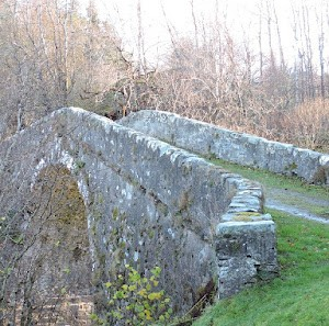
Here is the White Bridge, thought to gain the name from original colour of the stonework and built by Wade in 1732.
The walk took us downstream of the bridge along the bank of the Foyers River.

The sky was blue, but it was pretty cold at this point.

It really was a glorious day for walking.

You could see for miles and we were, in fact, looking across towards long abandoned townships as well as the site of a Pictish cemetery. Not that you can see them from where we were.

As we approached Dell Farm, it didn't take long for the forecast cloud to appear.

We had obviously aroused the interest of the locals.

Everywhere we walked there were huge numbers of Rowan berries on the bare branches of the trees.

Everything is becoming more skeletal, as if the vegetation is shrinking back into the land and leaving only a husk behind.

Dell farm was quite tidy, but very muddy. Mud seems inescapable round farms.

There was a bit of a commotion behind us as first two Red Kites and then a Buzzard were mobbed by a flock of crows, or rooks. It was too far to be able to tell. A group of crows are usually known as a murder or a storytelling. Presumably it would be a whodunnit!
Rooks, on the other hand are a Parliament or a clamour. Order, order!
In any event, they were quite far a way to get a decent photo. What was notable, was that the Kites actually landed in the trees, but the Buzzard flew off, with the rooks/crows in attendance. Then, later, the Kites flew up from the trees unmolested.

As we walked out, it became a little more bleak, which was a bit odd inasmuch as there was a stream and a hill (not in the photo) called Allt (stream) and Tom (hill) Aiteachaidh. Aite is a place and the name would indicate that it was habitable and cultivable. Sure enough, there is some archaeological evidence of a farmstead close by.
The rounded rocks on Dave's right look to me like Roches Moutonnée. These are formed by the movement of glaciers. They are smooth on one side and rougher on the other, indicating that the glacier was moving from left to right, if these are actually Roches Moutonnée.

Dave found them irresistible.

Still on a geological theme, I think this must be a sink hole

Not the Sycamore gap, but the birch gap.

The sky was getting a bit more ominous as we progressed northwards. The abandoned farmstead was thought to be here on the right of the photo. The land certainly seems to be more fertile here.

We walked down towards the first of three fords or stepping stones on the route. As you can guess, it was raining a bit by now.

We navigated the stones with scarcely a slip.

Nearby was a forage crop for pheasants to feed and shelter in.

Also nearby and completely unknown to us was Bonagour's Cave. This is an anglicisation of the Gaelic Bonaid Odhair, which means Dun Bonnet. Dun Bonnet was actually the nickname of James Fraser of Foyers. He wore a dun (brown) bonnet. Bonaid Odhair was also the name of Foyers village itself. This was quite handy for Fraser. He had survived the battle of Culloden and was on the run. He hid in this cave for a number of weeks, although most of the villagers knew this. As the village and Fraser had the same name, the villagers could talk about Fraser and nobody knew they were really talking about Fraser and where he was hiding.

We were heading into a somewhat different landscape.

We were soon into the trees.

We emerged from the trees and then crossed the River Foyers via an old estate bridge of unknown age. It was thought to have been built by the Frasers of Foyers. You get a nice view of the Upper falls of Foyers.

Nearby you get a good view of the Glenlia Intake, which is an integral part of the Foyers Hydro Scheme. The scheme here generates 5MW, but it is a small part of the wider pumped storage scheme using water from Loch Ness.

We were needing a bit of power ourselves, so we stopped off at Cameron's Café for soup and sandwiches. Luckily they were expecting us all and they looked after us very well. The soup and sustenance were excellent and very much needed after a fairly damp walk.
Dave, Robin, Susan and Sandra got high chairs as well.


We could have called it a day after lunch, but some of us decided to walk back to the hotel. Remarkably, I was one of those.
It wasn't long before we spotted something we missed on the way to Foyers - a picnic bench for birds!

We were heading into the sun and soon we were heading in to some rain.

Indeed, the sun was just around the corner.

So was the rain, but we did get a bit of shelter in the woods. Further away from the path is Carn a' Bhreabadair, the Weaver's Cairn. I cannot find anything about this, but there has to be a story there, I think.

As we progressed towards Whitebridge, the weather was closing in and it was a bit miserable at times. Not only that, but the temperature was dropping and the rain was falling as snow on the hills.


We did get a blink of sunshine as we passed by Dell Lodge. This is an 18th Century Georgian mansion in the middle of the 7000 acre Dell Estate. The estate is owned by the Finnis family who live mainly in Essex. Jeremy is a Deputy Lieutenant for Essex, so I could have chatted to him about Lieutenancy matters if we had bumped into him! The estate has a very good reputation for sporting pursuits.

The colours brightened a cool afternoon.

was our quizmaster for the evening.

Day 3 Sunday 17th November
Another cold day, with snow creeping down the hill. It was a bit forbidding to look out at whilst we had breakfast.

After our breakfast, we got ready to go, but not before a group photo outside the hotel.

There haven't been many group photos on this blog, but then two come along at once.

From the old White Bridge, you can see the newish one.

From the bridges we pass through some holiday lodges, before getting up onto more open country.
The Brown family seemed to have enjoyed their visit here.

The area we were walking through skirts past the remains of a deserted township. Additionally, there are at least 3 much older Hut Circles, probably of Bronze Age. There is a much reduced hill fort here as well, so the area was well populated over a very long period of time.
The hill in the picture is Beinn Sgurrach - sgurrach meaning rugged. No dubiety there, I think.

The contrary hill had a fine dusting of snow.

There were some fine views to the south back from here.

Our route took us off the open hillside and into a plantation.

It was downhill through the trees.

The wet trees, with an attendant risk of water down the back of your neck!

This dam across the River Fechlin forms part of the Foyers Hydro scheme. Some of the water from the river is diverted to Loch Mhor, which then forms part of the Foyers pumped storage system.

If only I knew what they were all doing here! It looks like some sort of square dance.

Only Liz had raised up her eyes and spotted the hinds on the skyline. Trust me I managed to photo at least one, just where the electricity line meets the profile of the hill.

Honest!

This roaring gate to hell, is probably something to do with the abstraction and transfer of water from the river to Loch Mhor.

The stone and/or concrete platform on the other side of the river must surely have to do with the construction of the dam. There is nothing in the archaeological record that I can find.

You can see how low the river is once the water has been abstracted for the Hydro scheme.

Climbing back up from the dam we were really fortunate to catch a glimpse of aon-adharcach. A unicorn for non-Gaelic speakers. Literally it means one horned. There are some who say that unicorns are not real. Given how close we were to Loch Ness it is plain that is not the case. White unicorns are sacred creatures and can only be hunted by virgins. Luckily we were not hunting for it, it just appeared.

Just past the unicorn and looking back to the snowy hills.

It was a bit of fight to get over the locked gate and, yes, we did notice that there were no fires. It was absolutely freezing!

There were lots of dripping, bejewelled rosehips.

We were heading back towards the hotel by now. The hill in the distance is Tom Rathail, where there once stood a little chapel. I wonder if the chapel gave rise to the name - it means auspicious or fortunate hillock!

Through the lichen covered birch you could see Hansel and Gretel's log house. It is a bit twee looking, but of course, the story of Hansel and Gretel is far from twee. Basically, the woodcutter and his second wife and family are starving. He tries to abandon the children in the woods so that they will have two less mouths to feed. Child abandonment was widespread in times of famine and poverty throughout middle age Europe.

This is the Allt Breinag, which flows into the Fechlin at Whitebridge. The burn has come from a long way away, heading in the direction of the Corrieyairack Pass. Brein seems to be smelly or putrid, although it looks pretty clear, if uninvitingly cold, to me.

On the side of the burn is Cnoc an t-sionnaich - the knoll of the fox. Another place with a story, you would have to think. Is it just where foxes live? Was there someone who was known as fox-like?

It was a short walk along the old military road to the Hotel and the cars.

It was a bit of a longer drive back to Inverness and Simpson's where we had arranged to have lunch or cakes, depending on peoples' appetites.
We did have a bit of a wait for a table, which gave Jimmy the opportunity to make a spectacle of himself.

Once seated, we had something nice to eat and that was the end of another great weekend away in good company.

Thanks are due to Sue and Charlie for all their organisation and liaison with the Whitebridge Hotel, Cameron's and Simpson's. Without provisions we would never have got through the weekend.
Thanks also to Jimmy for the entertainment and to everyone else for making Dave's late birthday memorable.
See you all next year!
posted by bobcam | 1:14:00 PM
|
0 comments
![]()