
LOOKING FOR THE WHITE BRIDGE PHOTO
Day1 Friday 17th November
Christmas is coming far too quickly, so it was time for the Dinosaurs to have an exciting weekend away. So, naturally, we were meeting up in the big cold car park at Fort Augustus. Exotic, or what?
Hugh sang a wee shanty, Pam clapped in time and Jimmy did a bit of a jig, all just to keep warm, or to pass a bit of time.

You can see Sharon's hand creeping into the photo as she checked her watch for the umpteenth time.

There's always somebody who has to arrive last, but not late as the Pollocks, along with Maureen and Liz arrived with 2 minutes to spare.

Then we had to say hello to everyone and get all the gear on, ready for the walk. We must have been delayed by at least 7 minutes.

I think Robin's decision to remodel the front of his car was a little over the top - they had only driven from Inversneckie!

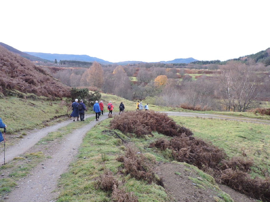
We were soon on our way, striding out and over the River Oich.
In an interesting (to me, at least) bit of continuity with our last away weekend at The Old Pines in Spean Bridge. The next two photos show the remaining piers of the bridge that once carried the Spean Bridge to Fort Augustus railway. We walked alongside part of that railway in April and here we were at the other end in November. The railway closed to regular passenger traffic almost exactly 70 years ago to the day - 1st December 1933.


In just a few steps we crossed our second stretch of water, the Caledonian Canal. We have walked along a fair stretch of the canal over the 17 years we've been doing this. This little stretch is famous for being the point where Sharon and I moored our superyacht with Sharon's sister and her husband in 2014 and walked up to the village to the local chippy. I'm surprised there isn't a blue plaque to commemorate this momentous occasion.

There is something to commemorate Queen Victoria's Diamond Jubilee of 60 years on the throne from 1837 to 1897. This rather ornate drinking fountain is not in the original location, having been moved from the aptly named Fountain Cottage, when that house came into private hands.

Soon, we were heading out on the South Loch Ness Road, kicking through the autumn leaves.

There were a few leaves, hanging on in an act of meteorological defiance.

We weren't the only people who had been here. I spotted this Dortmund Ultras sticker on a roadside bollard. Quite why some German football fans were here, I don't know.

Our third stretch of water today - the River Tarff.
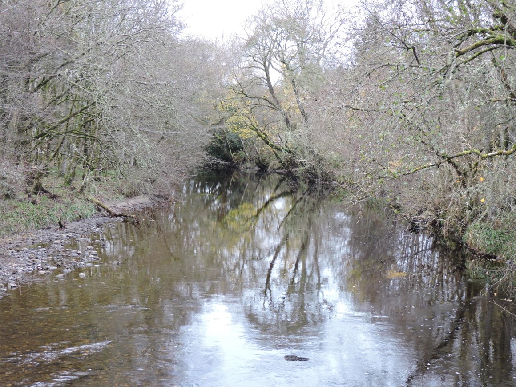
The altogether bigger stretch of water - Loch Ness. It holds more water than all of the English lakes put together.

We crossed the road, passing a small derelict building and soon began to climb towards the Ardachy Road. Little did we realise the historical significance of the building, nor indeed, this overgrown waterway beside the track.
This, and the small building, are the only remains of a hydro electric scheme. The building was the turbine house. The scheme was built by the monks from Fort Augustus Abbey in 1890 and it supplied power to the Abbey and 800 villagers. It was the very first hydro electric scheme in Scotland to provide electricity to the public.
It was shut down when mains electricity was supplied to the village in 1951.

The moss on the hydro lade indicate a pretty damp environment and this is why the large Lungwort Lichen can be found here. These large, leafy lichens are found all over the world, but they are in decline. The Highlands are a stronghold for them in the UK.

It doesn't take long to reach Ardachy Bridge, which carries the old military road across the River Tarff.

Time for a bridge photo.

Up the old military road we went.

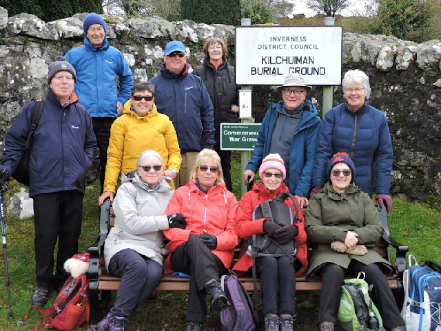
We cut off the road and onto a track taking us back towards Fort Augustus and into an old graveyard.
There wasn't an easy way in, so up the stone steps and over the wall we went.


As you might expect, there were lots of headstones!
This is Kilchuimin Graveyard. The name Cille Chuimein would suggest that it was the site of a monk following Chuimein. Cummene was the 7th Abbot of Iona and in common with all the holders of this post sent out numbers of monks as missionaries. He died in 669. Fort Augustus and the surrounding parish were both known as Kilchuimin, presumably after this site. There is no church here, only the burial ground.
The earliest burials are mostly from the early 18th Century, however, there is a Mediaeval fort remnant nearby, so the site may have been in use for centuries.

There were a surprising number of Commonwealth war graves here.
Each could have a story to remember, given we were walking so soon after Armistice Day.
This is Private James Baker. He was enlisted in the National Defence Companies. These were set up in 1936 as Britain began to re-arm in preparation for war with Germany. Enlistment was restricted to ex-armed forces personnel over 45 years of age. They became the foundation of Home Defence Battalions. I cannot find how he died within 8 days of the start of the Second World War, but it may have been accidental. The first recorded British Forces casualty in the war was in December 1939 and involved a British patrol in France walking into one of their own side's booby traps at night.
James was the husband of Henrietta of Fort Augustus.

Private A McKenzie. I cannot find his first name. He died of pneumonia in January 1915. His parents lived in Fort William, not very far from where I used to live. I suspect he was buried here, as Fort Augustus Abbey was used as a military hospital during the First World War.

19 year old Able Seaman Angus MacIsaac was stationed at HMS Vivid, which wasn't actually a ship, but the naval barracks at Devonport. All naval shore establishments were named as ships, because the naval rules only applied to men and women serving on a ship of his majesty, thus HMS Vivid was Angus's ship.
The Gaelic inscription reads " Until the day breaks and the shadows flee away". Angus was from Paible in North Uist.

Private K MacLeod, on the other hand, was from Daliburgh in South Uist. He was a piper with the Cameron Highlanders. His sister, gave an address in Glasgow for him. Once again, I cannot trace his first name!

Ronnie MacDonald was a local man, sone of Peter and Mary Ann and he served in the Royal Engineers. Details about Ronnie are scarce.

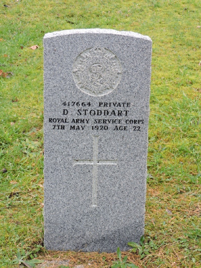
Private Stoddart was also from Fort Augustus and his parents lived at Bruce's Buildings in the village. The address doesn't seem to exist any more. The Royal Army Service Corps provided services such as drivers, postmen, logistics and the like to keep the fighting battalions operative. Again, I do not know his first name and he died of pneumonia in May 1920, well after the end of the hostilities in November 1918, but before the official peace treaty was signed in June 1919.
It is because of the delay between the end of fighting and the signing of the treaty that some war memorials say 1914-18 and some say 1914-19.
Another who died after the end of fighting (at least in Europe) was Rifleman Jack William Weir. He died in July 1945 a couple of months after the German surrender in May that year. The Rangers were part of the King's Royal Rifle Corps and fought in North Africa, before they were involved in the D Day landings and then into Europe until the end of the war. Given Jack was only 19 when he died, I suspect he did not fight in North Africa. He came from Bernera.

Another soldier, whose first name I cannot find. R MacLean was also another Cameron Highlander and his parents lived in Market Hill in Fort Augustus, which is within sight of the cemetery! He is the youngest serviceman buried here at only 17 years old. He served in the 4th Battalion which at the time of his death had not been deployed to France. I cannot find any information as to how he died.

Staff Sergeant John Wood Robertson Smith was another local man. His father owned the lair where he is buried and his address was given as Lochunagan, which is just outside Fort Augustus on the way south to Fort William. He served with 100th Provisional Company of the Royal Army Service Corps.


This way.


Maureen was rightly scandalised.


The Corps dealt with supply and transport for the army. The Provisional Companies were made up of men, who would normally be in reserve forces and so based at home rather than posted overseas.
As with many of the servicemen buried here, John died after the end of hostilities in April 1919. I suspect that many of those soldiers buried here had been hospitalised at the Abbey, except, perhaps, for those with local connections.
Somebody who was neither local nor a serviceman, was the Gaelic Bard, Archibald MacDonald. He was well known for his satirical poetry and songs. He died on his way to Inverness, where he had hoped to have his work published. He had stayed at Fort Augustus with a local schoolmaster who he knew from Uist. Much of his work was lost after his death and there is a hint of a suggestion that the schoolteacher may have published the work.
His nickname was Gille na Ciotag - the left handed lad. However, he was not left handed. In fact his left arm was shorter than his right, but he wrote with his right. The story is that the Laird misunderstood his mother, when she explained the boy's disability and the name stuck thereafter.
The Gaelic at the bottom of the plaque refers to Archibald being at the height of his powers.

After all of this interesting history, it was time for lunch.
There's always a lunch photo. As you can see, it is impossible for them to look at the camera!

Dave came back and they all faced front at last!

It might be Autumn, but there are still signs of life. Lots of Hazel catkins as we walked along the side of the river Tarff.

Once back in the village, we crossed over the golf course.

It wasn't packed with avid golfers - we could have brought our clubs and had a few holes.

It is just a short hop up onto the canal towpath from the golf course, although there does seem to be some indecision as to which way we should walk!

Not that way, was the answer.

This way.

The canal water was remarkably calm.

It's been some time since this boat went anywhere.

It is a bit hard to comment on this, but I know some people who can do this for free.

Looking down the flight of locks towards Loch Ness.

A man made waterfall.

Another bridge (almost) photo with an infinity pool below.

Then it was back to the cars and off up the hill on the south side of Loch Ness. It was pretty misty on the way up out of Fort Augustus, but when we reached the viewpoint at the highest part of the road, we emerged from the mist with some ethereal views in all directions.
Spectacular.


We were on our way to our digs for the next couple of days - The Whitebridge Hotel. They were very welcoming and happily allowed us to commandeer the lounge and move all the furniture, so that we could make merry.
Had they but known our past, they might not have been so trusting.
Sue and Charlie arrived to join us and we all had a tea, coffee and some Tunnock's tea cakes and caramel wafers.
It didn't take long to start telling tales of old times. At our age, some of these old times are positively ancient - and all the better for it.

It was more exciting than it looked!

Bizarrely, we got involved in Chinese whispers based on a card from Games Against Humanity. It ended up as Sesame Farts, but that sure wasn't how it started out.
Note that the tea cups have been replaced by alcoholic drinks.


After a wee livener, we got changed and ready for dinner and a group photo taken by one of the younger staff who didn't realise that we have a combined age of close to a millennium!

Then we repaired to the Dining Room.

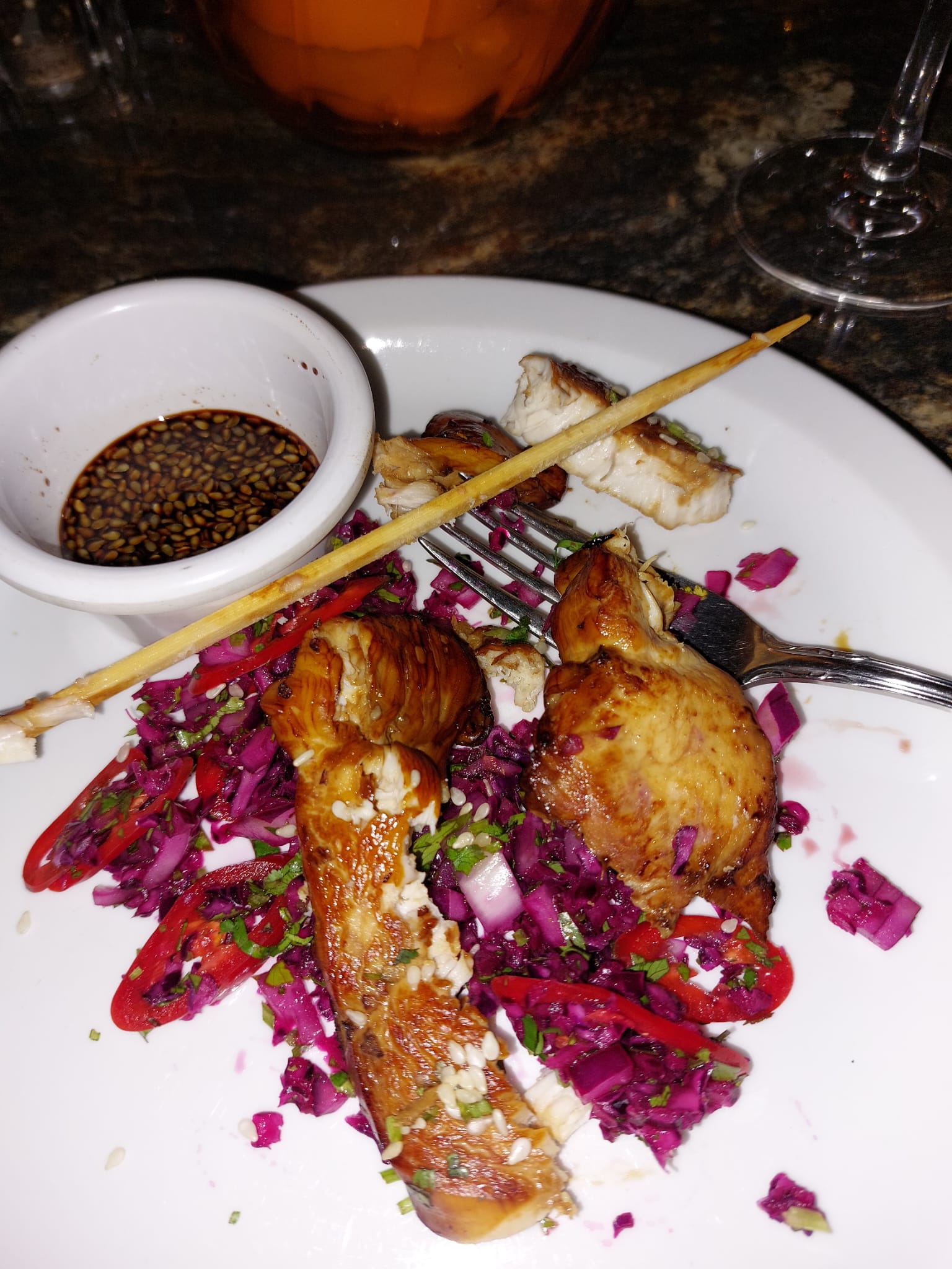
We were certainly well fed. I had a very fine Teriyaki chicken skewer with a wonderfully spicy dipping sauce and a zingy slaw.
Others had haddock goujons, which they professed to be very good.

Chicken Ballotine with haggis, mash and kale.

Cod fillet with chorizo mash - fab.


After our thoroughly enjoyable dinner, we were back in the lounge for games from Jimmy and a cabaret from Francie, or was it Josie.


Then Chick Murray came in, much to Sandra's surprise and delight!


Finally, Dave came in.

That was enough for the day and we all went to bed, well fed, happy and tired.
Day 2 Saturday 18th November
Saturday dawned a bit dull, windy and cold. Just what you want for a good walk!
Undaunted, we assembled in the car park to sort out the logistics of the cars for the day.
The vanguard dropped off cars at Fort Augustus and the rear guard were due to meet the drivers at the Viewpoint layby courtesy of Charlie. However, when we got to the layby, it was almost impossible to open the car doors, such was the ferocity of the wind and the lashing rain. A fairly quick decision was made to reconvene at Loch Tarff and walk from there. It would be not so high and exposed and the rain might have eased a bit by the time we were ready.
This was a bit of a shame.
The viewpoint is spectacular on a good day and the views from the walk would have been very fine. Additionally the viewpoint is actually known as Suidhe Chuimeinn - St Chuimeinn's seat. Now, if you had been paying attention to yesterday's meandering scribbles, you would remember that Chuimeinn gave his name to old Fort Augustus and he didn't just sit on his laurels, but he, or much more likely, a disciple of his, apparently sat up here as well.
Anyway, we didn't take in the view, because well, we couldn't actually see it, so we high-tailed it to Loch Tarff, pretty sharpish.
Loch Tarff is the water supply for Fort Augustus and it also featured in Local Hero - pretty good for a wee Highland loch. It sits nearly 1000 feet above sea level and was formed in the last Ice Age about 10000 years ago by glacial action. Despite what you might think, the Loch is not the source of the River Tarff that we walked along yesterday. The outflow from the loch passes under the hill known as Carn na Dreamaig, which means the cairn of the irritable or snappy woman. Clearly not named after anyone we know. The burn then flows into the Allt Doe, which we meet up with later on the walk.
As you would expect from a movie star, the loch is beautiful - even on a grey day.

Here we are gearing up for the elements.

It didn't take us long to get going on the South Loch Ness Trail and we were soon up close with some wildlife.

He was a fine looking stag, but he seems to have broken a bit of his antlers, perhaps during the recently finished rut.

There were some hinds further up the hill, but I was a bit slow and only managed this blurred behind going behind the hill!

Looking the other way, there were fine views over Loch Tarff. The island in the loch is Eilean Ban, which could mean the vacant or empty island. Ban also means fair and if you went in the opposite direction to the way we were going you would get to the Fair Haired Lad's Pass. I'm no conspiracy theorist but.....

This island, which is not named on the OS map, looks a bit drowned. The existence of trees would indicate that it is never grazed. Eilean Ban, on the other hand, has no trees, so perhaps our staggie friend nips over for a browse now and again.

The trail is very good and took us south west with a degree of ease.

Looking back towards the viewpoint and our intended start, suggested that it was still a bit wild up there. It had stopped raining where we were.


It may have stopped raining where we were, but the view where we were going was a little on the apocalyptic side.

There were some signs of brightness to the north, but we weren't going there.

The apocalypse didn't arrive and the weather improved significantly.

Against all etiquette and rules of decency, Jimmy started handing out sweeties and everyone knows this is Maureen's job.

We were taken aback by this flagrant breach of rules, but carried on once we had had one of his mint sweets.

You might have noticed that we had been walking through pretty treeless moorland. These birch are the remnants of a wider forest. There are next to no young trees here, because of grazing by deer and sheep. This woodland will eventually disappear.

Down by the river the woodland gets thicker and more healthy because it is more difficult for the deer and sheep to graze the young saplings.
Another bridge photo opportunity.


We stopped for a look and Maureen handed out some more sweeties.

From here, we walked up to the public road and got a view of the bridge carrying the old military road over the Allt Doe. The bridge is said to have been built by General wade about 1730 and was rendered redundant when the road was realigned.

Just along from the bridge, someone had cut down some alder trees. This would not have been countenanced years ago. Alder were considered unlucky to cut. The pale timber soon turns orange/red when exposed top air. This has given rise to all kinds of legends about alder holding the souls of our ancestors and the red colour representing their blood which flows from the tree. The trees were considered such bad luck that some people would turn back on their journey if they had to pass one. We had no hope today, we must have passed hundreds.
On a more positive note they were often used in the construction of crannogs, because they become as hard as iron when submerged. Quite how you overcome the bad luck involved in chopping them down to make your house is a bit of a mystery. You don't wany your alder crannog to go on fire, either. The wood burns with a particular ferocity, making them useful for charcoal making.

After leaving the river and the alder behind we started climbing up the slope watched by this faraway buzzard.

We soon came across some enigmatic numbers.

The mystery was quickly solved. These were stances for shooting pheasant. Apparently over 45 million pheasants are bred and released on shooting estates every year. They are driven by beaters over the gun stances. the various numbered stances here seemed to use different cartridges. I have no idea which are the most efficacious. They are probably less effective than nature as the vast majority of bred pheasants live less than a year in the wild.
Pheasants were introduced to the UK many centuries ago, but shooting them became a thing only in the last 200 years. They are quite tasty, but they can be injurious to your fillings!

Perhaps the guns had scared the deer further up the hill, or, more likely, they didn't want top be too close to us. In nay event, they were pretty far away on the the skyline. Honest!

Not the sycamore gap, just a lonesome and half fallen over rowan.

A first glimpse of Loch Ness far below us.


We had been descending for some time, but now we were really going downhill and so was the weather.

Some hefty rain was sweeping in from the west.

This was the last photo I took on the walk. I thought it showed quite starkly the difficulties of growing in the Highlands. The soils are really thin and overlying bedrock. There is precious little nutrient and even less material to hold on to.

It was very wet by now, and the constant downhill stress on my knees was beginning to tell.

A merry drookit band were waiting for me at the bottom of one of the hills.

It turns out they weren't waiting for the walking wounded, they had, quite by chance been passed by Sue and Charlie on their way back to the hotel.
Clearly, this was meant to be and I took advantage of this serendipity to get a lift back to the hotel while the drookit dinosaurs carried on bravely without me.

They soon reached Loch Ness, as the rain careered eastwards to Inverness..


Jimmy was tempted to the waterside and a duck tried to swim into his ear.

It wasn't just ducks on the water.

It was lunchtime as well and what better place than by the shores of Loch Ness.
I don't know what it was that Jim and Jacque were eating, but they were eating it alone!


Everyone else was under the boughs of the trees.

They did get back together for a lunch photo.

Unfortunately, I could not join them. I was marooned in the bar at the hotel next to the roaring fire. Oh, how I missed them all.

Luckily, I was not on my own Charlie was with me and Sue took the photo. I have no idea where the beer came from!

Meanwhile the rest of the dinosaurs were walking into the village, which was apparently heaving with tourists.

The Spirit of Lech Ness was in along with the attendant crowds. It can hold over 200 passengers and it looks like they were all there.

More rain on the way, it seems.

It wasn't long before they had finished the walk and were on their way back over the viewpoint on the way to the hotel, and they could see a great deal more than yesterday!

Once back at the hotel, it was time for everyone to get warm, have some tea, drinks and chat before dinner and more drinks and tom foolery.
Tonight's dinner included an amazing Iron Bru pulled pork spring roll. It was fantastic.

The garlic mushroom starter was also very good, I was told.

As was the Thai salmon.

The venison stew and doughballs were much more controversial. The doughballs really divided opinion. Certainly Robin and I liked them, but most others did not. Some also found the venison stringy in part.
Not a stunning success for some, it would have to be said

Nonetheless, we all went to bed, happy after another good day out.
Day3 Sunday 19th November
Our final day in Whitebridge.
After breakfast we assembled in the hotel car park, with some of us taking the cars down to the bottom of the hill, where we were to end our morning's walk.
Here are Sharon and Hugh limbering up for the walk, or trudging back up the hill.

Here is our hotel. It has changed considerably over the years. It is thought that what we see now was built on the site if a Kingshouse built around the time of construction of General Wade's military road. when the road was built in 1726-27, camps for soldiers and workers were built at 10 mile intervals. It was common for inns to then be built at these sites and these inns would expand to serve the traveling public.

Here we are ready for the off.

Off along the public road we went, in the footsteps of General Wade.

I'll bet the old general didn't have to put up diversion signs, or, perhaps, nothing has really changed.

In truth the old track is on the line of the military road, so all was well.

The river running below us was fairly turbulent, which is aptly given the Gaelic name of the Allt Breineag, which means turbulent, although it is often applied to women in a less than flattering way, as in a dirty, bad tempered, sulky slut.


The sign announces Fechlin House, which must be named after the River Fechlin, into which the Allt Breineag runs just behind our hotel. I cannot trace a meaning for Fechlin, but I wonder if that is what the gargoyle is doing?

Some blue sky, surely we would stay dry today!

This may be a comment on house prices hereabouts or a reference to opportunities to spot the local wildlife.

This is Beinn Sgurrach, which is about 1550 feet high. The Gaelic translates as the rugged mountain, which seems reasonable to me.

Remarkably we stumbled on Hugh and Pam's house. It seems to me that they've really let the garden go in the few days we've been away.

Oh no, the Fechlin Intake. I can hear hundreds of teachers saying that every August!

The gate was not open, so over the fence we went.

I'm not sure if the horse was disapproving, or just bemused.

There were more deer louping up the hill, but I didn't catch them. They were going so fast, it was a blur.

As we were walking down to the intake dam, we spotted an Eagle in the sky, but again it was too fast for me!

Here is the dam and this controls water in the river and abstracts water for the wider Foyers pumped storage scheme.

The intake looks a bit on the spooky side to me. I had almost forgotten that Hugh described it as an oubliette, which everyone knows is a dungeon where prisoners were consigned to and forgotten about in the olden days. Hence, the name oubliette - from the French oublier,to forget. Starvation was the usual cause of death. Dehydration was presumably an issue, but not in this case!.
The noise was astonishing.

It was a pretty eerie place.

I find that hydro dams have a strange kind of beauty, lots of curves and interest, despite the concrete. Just oublier that I said that.

Further upstream was a strange sight, which I think was designed to catch large debris such as tree trunks getting into the dam.

From the dammed waterway, we moved to the damned gate/fence and steep, very muddy track.

Intrepid Dave showed the way.


With help!

Oh bugger that, I',ll cope, said Maureen.

Another view of the rugged hill, above which, we were promised, the sky would be black with eagles.

Luckily there were some fine views to distract us from the paucity of predatory birds.

There was a fleeing deer.

There was also a kite flying by. Quite far away, to be fair.

There was a curios sheep as well.

We could also see the back of the hotel by now.

We were now walking through the remains of a deserted township of sufficient size to have had a number of corn drying kilns. The township itself lay in the shadow of a much older fortress, so the area had been settled over many centuries.
Whether this pile of stones was part of the township I don't know. They could just have been a sign of field clearance. I should have gone for a look!

There was an unexpected pond, which seemed man-made, possibly for shooting purposes?

In no time we were at the bridge that gave its name to the village.
The bridge was built on 1732 on the military road. It is thought to have been supervised by General Caulfeild, who's old house a number of us live close to!
The stonework was white in colour - hence the name of the village.
A fitting spot for a bridge photo.

Sharon insisted I prove that I was there.

You can clearly see the hump back of the bridge and it is one of the finest examples of a single span hump backed bridge by Wade.

That was us back at the cars and ready for a bite to eat.
Off we went to Cameron's at Foyers for a pretty good soup and sandwich lunch.
Sue and Charlie joined us for luncheon and Sue took this photo of us all enjoying our food, including some tea and cakes!

Many thanks are due to Jim and Jacque for all their organisation of accommodation, walks and parlour games. The hotel was a joy and the staff were fantastic.
We will be back!
posted by bobcam | 4:07:00 PM
|
0 comments
![]()