
OUT AND ABOUT FAIRBURN OR IN?
A new year and a new walk, that was actually an old walk. It may have been done before, but not by all of us, so it was a new walk for some of us, if you follow.
We met up in the snow and sleet on the road to Fairburn Tower, near Marybank. The weather was not very clement, so much so, that even the local snakes had to wrap up to keep warm.

Here is Hugh putting on his hand warmer, while Pam and Agnes get down in the hood.

JImmy, meanwhile took shelter under the boot door, while Sandra, Dave and Jacque stayed in the car.

However, we are a walking group, so walk we did as the clouds rolled ever nearer.

It was a little dreich, to be honest. Bizarrely, dreich was voted the most popular Scots word in 2019! The first recorded usage of dreich was in 1420, when it originally meant enduring, slow or tedious. Even more bizarrely, it is derived from Middle English of Germanic origin and it is related to Old Norse drjudr, meaning enduring or lasting.

It is no real surprise that the weather was so poor, we were at nearly 500 feet above sea level. That kind of elevation means the soils are pretty poor as well and some evidence of that can be seen in these lazy beds next to the road. Lazy beds were constructed on poor, thin and often wet, soils. Drainage channels were dug first and anywhere between 3 and 8 feet apart. The soil removed from these channels was piled between channels and, so, became a bit higher. This meant they were less waterlogged and a bit warmer. They would also be fertilised, often with seaweed. You can see the principle working with the water sitting in the drainage channel at the bottom right hand side of the picture.

Things have moved on since the days of the lazy beds and modern practices allow dairy farming to take place at this altitude when that would have been unthinkable a hundred years ago. The cows still need to be overwintered inside, though.

In no time, we were in sight of Fairburn Tower. The tower has a long and chequered history. As happy as I am to disappear down endless rabbit holes, I will try and keep it short.
It was originally built by Murdo MacKenzie some time after 1542. It was then that Murdo was granted the lands around here by King James V. Murdo was described as a Graceful youth and he was one of King James's Gentlemen of the Bedchamber. Obviously a worthwhile bit of employment for a graceful youth. He built the original house, including the gun loops that we saw at the lower level. Times were pretty rough then and defence was essential.
The MacKenzies did pretty well for themselves and added to the tower over the centuries. The bartizans (the round roof turrets) were added in the the 17th Century.
However, the estate declined after Bonnie Prince Charlie's escapades and the tower fell into decay. It was around then, that the Brahan Seer's prophecy came true. He had predicted that the MacKenzies would lose everything, the castle would become uninhabited and that a cow would give birth to a calf in the upper chamber of the tower.

The building was ultimately saved by the Landmark Trust just after Covid and it is now available, like all Landmark Trust properties, as holiday accommodation. 4 people can stay there for £424 for 4 nights. It will be available to wander round on Doors Open Day on Sunday 14th May this year if you want a nosey.

During the renovation, the courtyard was uncovered while trying to find a foundation for scaffolding. It has been left open so that guests can better understand the whole complex that once existed here. The small ruined building to the back of the tower was a later addition and was originally thatched.

We left this impressive building behind and headed down to the River Orrin.

The sun was trying desperately to get through the murk.

It succeeded. So while it had been dreich, it had not been enduring!
e

The sunlight was reflected in countless raindrops caught in the bare branches of the trees, glistening like a myriad gossamer spider webs.

There was even a blue sky to be seen.

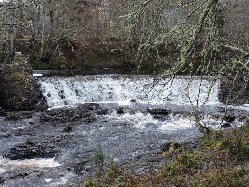
At the bottom of the hill we arrived at the Orrin Hydro scheme. This was built in about 1898 and it provided electricity for lighting in Fairburn House, some distance to the west of the tower which it had replaced. Water flow was regulated by the concrete box sluice lade and the metal sluices. The scheme was altered a few times before being abandoned in the 1960's, when the major hydro scheme was started in the upper reaches of Glen Orrin. However, it was refurbished and brought back into use and provides electricity to the estate now.

Some of the Dinosaurs were enthralled by the works.

Onwards alongside a fine stone wall, which seems to retain the track from falling into the river.

There are some significant trees on Fairburn Estate. These were mainly planted in the 1870s by the owner John Stirling. They were measured by Alan Mitchell in 1982, when there were 60 trees over 100 feet high and 10 that were over 150 feet. This Noble Fir is certainly pretty tall, if a little unkempt.

Many of the tallest trees are found in the vicinity of the Stirling family private graveyard, which was just to the left of the track we were following and behind the green fence.

I am pretty sure that Sir Roderick Stirling is buried there. He was the Lord Lieutenant to whom I was Clerk from 2005 to 2007, when he died. He was made a Knight Commander of the Royal Victorian Order by the Queen just before his passing. Such an honour is entirely in the gift of the monarch and is made without reference to politicians.

All along the retaining wall on the uphill side of the track is a nice stone wall. It has these recessed "funnels" which are used to channel small watercourses running down the hill, so that they do not spill out over the track.

Some people like to watch the water flow by, and this looks like quite a pleasant place to do just that.

This is the Aultgowrie Gate Lodge to Fairburn House, which is now a care home, rather than the very grand stately home it once was.

Maureen had brought some very nice posh sweeties for us all this time. Very welcome they were too.

We crossed over the River Orrin at this point, on the old bridge which dates from 1850. The River gets the name from the Gaelic meaning sacrifice or offering, which makes the sweeties all the more appropriate.

There was a redundant sign just ahead of us. It was far too damp to light fires.

From the other side of the river, you get a good view of some of the very tall trees.

Just bobbling along towards the west.

This took us back to the hydro scheme, where a couple of us stupidly went wandering to look at stuff and found ourselves on the wrong side of the concrete box sluice. We were, however, able to nimbly leap across the gap to re-join the group.

On we went....

... crossing a fallen tree. You can see by the worn moss where the short legged people crossed on the left, while the long legged crossed on the right as you look at it.

There were the remains of a house near the track. This seemed to be at an area known as Cornhill. There were actually a number of buildings shown on the map and a kiln is is marked further along the river. I don't know if it was a corn drying kiln, but perhaps this area was a bit more industrious than it currently appears.

Talking of corn, it was time for lunch and we quickly found a fallen tree to sit on. Jimmy checked that it was the right height to get up and down from without pain or grunting!

Just as we sat down, this Red Kite circled overhead. It either thought we were never going to get back to our feet, or that we would leave some tasty morsel for it when we left.

Robin started to take his boots off and Liz immediately whipped out her hanky to provide a bit of protection against any odours that might escape.

Luckily there was a bit of a breeze, turning the blades of this turbine on the Fairburn Wind Farm, and removing any hint of foot odour.

The first lunch photo.

The second lunch photo and Liz bends over backwards to get into the picture.

Then it was back on the road. Well, it was for Sharon and Agnes.

The rest of the luncheon laggards were a bit behind.

It must be a sign of something.
Immediately you think - NO PARKING. However, the sign below might lead you to NO BARKING. Anyone who can think of something better might get an extra sweetie from Maureen.

Once we started to climb back uphill to the tower and away from the river, views towards the east opened up.

You could even see Inverness which is getting on for 20 miles away as the crow flies.
Why do we say that? Nobody actually knows. Crows do fly alone across the countryside, but they definitely don't fly in straight lines and nor do most birds, unless they are migratory. There is a theory that crows were kept on boats before modern navigational aids were invented. The theory was that they were carried in cages and would be released from the Crow's Nest and fly directly to land. Not likely as crows are notoriously quarrelsome and would be ill suited to cages. They also tend to fly in wide arcs looking for carrion. Of course, in Scotland the Crow Road was the straightest road between A and B, but even Crow Roads were not dead straight, although the allusion to the Crow Road is now seen as a reference to death.
So, who knows?

Finally, we head past Tower Mains and it gives us a chance to reflect on the day.

It was really good to get out for a walk with Dinosaurs after the excessive festive. Well done to Agnes for arranging the walk and for ensuring that the blizzard conditions at the start did not continue throughout the walk.
Once we got back to the cars we were off for tea and cakes at Glen Ord Distillery.
After tea, three old men were very happy to be given a small taste of their 11 year old whisky.
It was very good and warm all the way down. We could have used it at 11 o'clock at the start of the walk!

It is good to be back for another year!
posted by bobcam | 4:03:00 PM
|
0 comments
![]()