Before I start this blog, I would like to apologise. Not because I went to a party! The issue is that this blog will not allow me to put accents on letters, so this means that some of the Gaelic used in the blog is not true to the language and, indeed, some words will have different meanings. I am hopeful that you will still be able to discern the meaning from the pictures, if nothing else!
Scroll on down.
Ciamar a tha sibh, a chairdean. Failte, gu mo brath-bloga Dineasaran.
Chaidh sinn gu Duras an-diugh. Thainig sibh aig na pairc-charaichean faisg na h-eaglais Duras. Cuin rainig a h-uile daoine a bh-ann, chuirt Uistean " Thugainn cuairt"!
I bet you're wishing you had read all these Gaelic signs, now!
Sharon says, I can't go on like this otherwise the blog won't be finished until 2023!
The translation is - How are you, friends. Welcome to my Dinosaur blog.
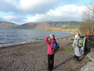
We went to Dores today. We arrived at the car park next to the church at Dores. When everyone had arrived, Hugh said "Lets go for a walk"!
Before we do that, a bit about the church. It is actually not as old as the churchyard. The yard dates from the 18th Century and the church was built in 1828. This would suggest that there was an earlier church on the site and, that was the case - there are records relating to the repair of the previous church during the 18th Century. The bell-tower is actually an even later addition to the church. The windows on the side are a little unusual in that they break through the eaves line a bit like dormers on a house. They are called long pointed-headed windows rising through the wallhead into finialled gablets. I say this, merely to illustrate that I would have spent a fair amount of time trying to translate that into Gaelic!
Here I am in the car park, arguing with the Philistines about the merits of Gaelic road signs!
A quick potted history.
During the 18th and 19th Centuries, there was a concerted effort to eradicate all traces of Gaelic. Children were forcibly made to learn and speak English. Ordnance Survey maps were made with English spellings or translations of the original Gaelic place names. Into the 20th Century, road signs began to be erected throughout the Highlands and County Councils at that time followed the antipathetic Government line against Gaelic. So, people were forced to call Mo Dhachaigh, Home. They could not use their own language to describe where and how they lived. Cumulatively, these types of intervention had the effect of discouraging people from speaking the language and eroding their heritage. Just the sort of thing that happened to First Nations North Americans or Australians. Nobody disputes the rights of Australian First Nations people to call their sacred rock Uluru.
The catalyst for change arose in Skye in the 1970s. The Council needed some land to build a road. Sir Iain Noble said they could have the land, but any road signs on the new road would have to be bilingual. The Council did not accept this offer and were then surprised at the public support for Sir Iain. They finally agreed to compromise and erect bilingual signs on a section of road, which established the precedent.

Gaelic road signs more accurately describe the places we are driving to and from. Dores is Duras in Gaelic, which is an abbreviation of Dubh Ros - The dark woods, and we would be going through some of these later on our walk. They are more historically and ethnically accurate. The English translations are not exact, so, in effect, Gaelic speaking residents are expected to guess where a particular place is. Fort William is an Anglicised place name. It was named after Prince William of Orange, who had precious little to do with the place. In Gaelic it is simply An Gearasdan - the Fort. Everybody who lives there calls it the Fort. Having the original name harms nobody. Of course, Dingwall is not the original name of the town - that is the name given to it by the Vikings. Before the Vikings it was the town at the mouth of the river Peffery - which flows through Strathpeffer to the sea at Dingwall or Inbhir Pheofharan.
Gaelic road signs are only erected as new signs come to be put in place or old signs are replaced, so the extra cost is not as big as some would have you believe. If you don't want to read the Gaelic names on road signs, just read the white words, there is the same number of these as there always was. Research by Transport Scotland found that bilingual signs had no discernible effect on road traffic accident rates.
Rant over, so onto the walk.
We walked alongside this converted steading next to the canalised burn. I thought the building might have been some sort of mill, using the water for power. In fact, the old grain mill was back near where we parked the cars; this building was a farm steading. The burn is actually called Allt a' Mhinisteir - the minister's burn. That makes sense as it flows past the church and the manse. Perhaps the minister had some historic rights over the water.
The burn flows into Loch Ness and it wasn't long until we were there as well. Here is the burn debouching into the Loch. It is a long way down the Loch - 22 miles to Fort Augustus. That meant that the wind was travelling quite far before getting to us and it was certainly cold.
It is probably impossible to walk on Dores beach and not stand and stare down the Loch.
We pass a memorial to Gregor McIntosh, who was killed in a car crash on the A9 just before Christmas in 2019. Presumably there was some connection to Dores beach and the flowers were placed there a few weeks ago in remembrance of Gregor, who was only 16 at the time of his death.
It certainly is a fine spot to be remembered.
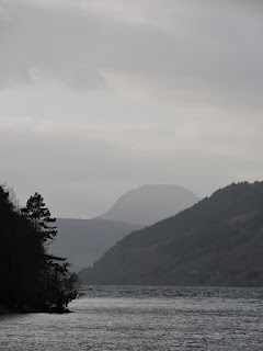
One of the most prominent landmarks to be seen from the beach is Mealfourvonie. It rises to 699 metres (2293 feet) at the highest point. It is a Graham and a Marilyn. Grahams are mountains above 2000 feet and below 2499 feet. Marilyns are mountains with a prominence of greater than 150 metres. So, Meall Fuar Mhonaidh, as it is more properly called, is a Marilyn, but Cairngorm is not, even though it is much higher.
The Gaelic name is descriptive and it means cold rounded hill. That is why a smattering of Gaelic allows one to better understand one's surroundings.
From the shores of the loch we enter the woods. Torr Wood on the map. Torr meaning small hill or conical hill or mound.
Perhaps these are the dark woods that gave Dores its name.
A wee stop to look at the loch.
It was also sweetie time - perhaps a bit earlier than usual, but nobody held back.
Looking through the lichen covered limbs of a birch tree.
It may not be immediately apparent from the picture, but this was a huge bird box, presumably for a large bird, because most birds prefer a box with an entry hole that is just large enough. Any larger and big things can get in and eat the birds or their chicks.
Coming up the loch is....
....the Jacobite Maverick. She is the latest member of Jacobite Cruises fleet, being built in 2018 at Wight shipyard on the Isle of Wight.
Another view of the cold rounded hill.
This old building currently houses a boat, which looks like it is used for angling. I suspect it was not originally built as a boathouse as that would normally be closer to the water than this is. However, I cannot trace any historical reference to it.
A sign advising us to follow the red route to avoid any danger as a result of works to Aldourie Castle and surrounding ground. We ignored that and followed the old route, to get a view of the castle. We would come back and follow the recommended route later.
By the look of it we were not the first to be this adventurous. If the route had not been used as advised since 2018, the path would have been a little less evident.
Aldourie Castle is a lot like your average Disney fairy castle. However, it dates from 1626, long before the magical kingdom was even thought about.
The Castle was the childhood home of a noted liberal politician of the late 18th and early 19th Centuries - Sir James MacIntosh. He was born in 1765 and died in 1832. He is famous for all sorts of philosophical, legal and political arguments. In particular his support for the principles of the French Revolution were, at one time, thought to be one of the pillars of liberalism as opposed to the reactionary right wing thought of the day. He later changed his views following publicity of the excesses of the Revolution. His book is considered by many as the best liberal riposte to Edmund Burke's Reflections on the French Revolution, which is still seen as one of the defining texts of modern conservatism in the UK. Margaret Thatcher was a fan of Burke.
As an aside, MacIntosh was also a founder of the RSPCA! A bit ironic that he should die as result of choking on a chicken bone and you can rent his house for a jolly big party or a corporate event.
With thoughts of chicken on our minds we went back to the beach for lunch.
In keeping with the more genteel and proper days of Burke and MacIntosh, James and Jacqueline had went and brung their own picnic paraphernalia with them.
Robin was so entranced by it all that he threw his soup all over the beach.
Here we all are in our sylvan snack bar.
The offending soup.
It may look like something an unfortunate dog might have done, but it turned out to be something that a fortunate dog just lapped up.
While the wee dug was lapping up the soup, Nessie was generating weaves to lap up on the shore unnoticed by almost all of us. She, known as Niseag in Gaelic only appears to true believers and Gaelic aficionados.
Here are the lapping waves.
Lunch and monsters were left behind us as we got back to the walk.
Like Dr Doolittle, I believe that animals can talk. Certainly, the Livestock here must be able to read the sign, because the gate was shut.
The woodland here was notable for the yellow colouring on the tree trunks. This is caused by lichens which tend to live and thrive on the north facing part of the tree trunk. This is because the north facing trunk is the side less affected by sunlight and so the less likely to dry out.
Bird shit. A good indicator of birds. I did look up, keeping my mouth closed, but there was nothing there, but it is clearly the well used roost of a biggish bird.
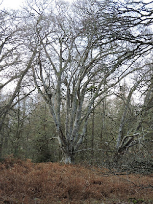
A venerable old beech tree. Beech are not native to Scotland. In fact, they are only considered native in south east England. Beech as a species arrived late to the UK, coming here only after the last glacial period. This tree is not that old and was almost certainly planted, probably as part of the improvement of the grounds of Aldourie Castle.
The brown at the bottom of the picture above is bracken. The spores on the underside of the leaf below is a fern. The spores on bracken are actually carcinogenic and care needs to be taken if clearing bracken in the late summer/autumn when the spores are easily dispersed into the atmosphere. These spores are ok, though.
Back down to the loch shore. There is a bit of flare on the photo, but it is still a bit atmospheric.
It is a view you might never get tired of looking at.
On along the beach we go.
There is nothing to stop the wind howling up the loch, so it can get to be a bit choppy at this end.
It was all a bit threatening, certainly not the weather for a swim.
Although some people obviously disagreed. I would have joined them, but I'm frightened of monsters. I would have embraced the cold.
A crepuscular ray shining through a hole in the layer of stratocumulus clouds. Like a torchlight from the heavens.
Heading back to the cars and away from the beach, we passed flocks of Greylag Geese, which probably arrived here from Iceland or Tesco in the late autumn.
Only joking about Tesco, Iceland is much more likely.
Once in the cars, it was back to Inbhir Nis to Hugh and Pam's house for tea and cakes, although there was a stop off at the local Mosque/temple/gurdwara. Maybe the shoes had been left behind as the wearers were abducted by aliens? Who knows?
Once inside, having been promised a firepit and barbecue by Pam and Hugh, we were, instead, treated to a delightful selection of sugary treats, tea and coffee.
It was a very fine walk, it had stayed dry and fine and the tea, coffee and cakes were just grand. Sitting inside was a bonus, so many thanks to Hugh and Pan for all the organisation and for putting up with our invasion.