
TORRIDON - THE PLACE OF TRANSFERENCE
November, and as is traditional, the Dinosaurs went away for the weekend. For the second time we went to Torridon and for the second time, the weather was pretty atrocious on the drive across. This was the view across Loch a' Chroisg, which is Gaelic for Loch of the Crossing. It is thought to be called that because it lies on the old cattle droving route from the west coast to markets in Dingwall and Inverness. This photo was taken in a moment of slight brightness in the first named storm of the winter - Abigail. At this point in our journey I was seriously thinking of calling a vote that we never come back to Torridon in November again.

However, we made it to The Torridon Hotel. We were not staying there, but at the Torridon Inn, next door. We were eating at the hotel in the evening, though.

The Hotel was built for the Earl of Lovelace in the 1840's and was designed by Alexander Ross of Inverness, who also designed and built the Cathedral in Inverness. Just in case you didn't know, the Cathedral was supposed to have had spires, but they ran out of money and the two towers you see now were all that they could afford. There are pictures of the Cathedral with the spires in one of the church annexes.
The drawings for the Torridon Hotel are hung on the walls of the corridor leading to the gents. However, I did not have time to compare the drawings with the as built hotel to see if anything was missing.
In any event we ate in the library and the meal was quite outstanding. It certainly was the best meal I have eaten with the Dinosaurs in over ten years of walking and eating ( except, of course, all our self catered meals).


After that bit of overindulgence and even more food at breakfast time, it was off to the first walk of the weekend - Lochs Clair and Coulin. This walk is well known and very scenic. It is a right of way due to a legal battle in the 1930s. It was originally built to allow the owner of Coulin Lodge, which we passed, to get access to the railway line at Achnashellach.
Here we are getting ready to start, as the weather begins to close in rapidly from the west.

It is always good to see the rain sweep in before it gets to you.

Setting off into the wind and rain, hoods up and heads down, thoughts turning to the Inn with warm fires and cold beer - or was that only me?

They were walking so fast that they flashed over the first opportunity for a bridge photo.

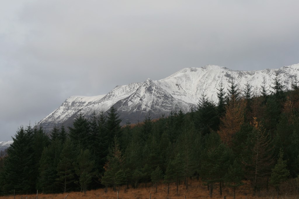
At this point, it was difficult to look up to the stunning Liathach - aptly it means The Grey One in Gaelic.

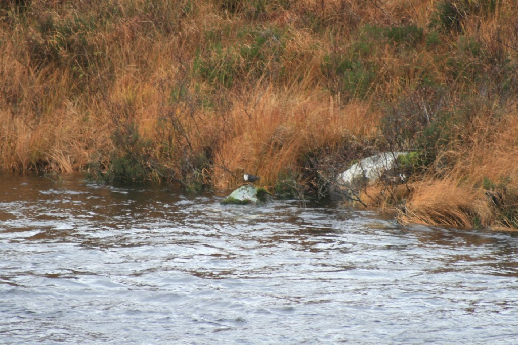
As the rain started to ease, it was possible to look about a bit more and spot the Dipper, Latin name cinclus cinclus. I would like to say that I know what that means, but it derives from the Greek kinklos, which just means "a kind of bird".
However, I do know that the Dipper is the only British bird that swims underwater and is aided in that by having bones that are uniquely solid amongst flying birds.
The Grey One gets a bit clearer.

Along the side of Loch Clair there was a stone wall of indeterminate age - probably Victorian. What was fascinating about it was the provision of semi-circular, columnar drains collecting water from the hillside above and so preventing it building up behind the wall and causing the wall to collapse. These were really neat and obviously effective. I have never seen anything like these before, nor can I find anything like them on the web.

One or two of them were square in section rather than semi-circular and they seemed to be just as effective.

The bridge across to Coulin Lodge. It is of a similar trestle-piered design to the Broomhill Bridge across the Spey at Nethybridge, once described as the finest wooden bridge left standing and operational in Scotland.

On to more open land and out of the trees, and the weather had improved significantly.
This brought us to Loch Coulin. The name Coulin is thought to mean high enclosure or collection of enclosures. It has also been suggested that Coulin is derived from Connlach, a hero from the mythology of Fingal who was supposed to be buried on a promontory in the loch at a location now unknown.
Here are our own heroes on the trail towards lunch.
Here are our own heroes on the trail towards lunch.

Looking back towards Coulin Lodge and Liathach. Just as an aside Coulin Lodge had to be harled to cope with a serious damp problem.

If Coulin was an area of enclosures it would surely show up on the ground and sure enough here are the remains of stone buildings.

These ruins were surveyed in 2011 prior to forest planting on the estate. The buildings are thought to relate to a possible township called Garran Chonlin, recorded by General Roy a military mapmaker in the 1750s.

Some of the remains may be of shielings.

One of the requisites for any kind of agriculture and settlement is the availability of water. Here is a series of photos showing Dave help various people across some water.


More views of mountains. You really couldn't take your eyes off them.

The photo below shows the view from the cottage at Torran Cuilinn - The low knoll of Coulin. The cottage, along with the larger farmhouse where we nearly had lunch, are both holiday lets.

The new bridge across to the farmhouse and an opportunity for a bridge photo, if only they don't run over it this time!

A Highland Cow in a Highland Glen.
Makes you think of toffee doesn't it?

This close, however, and you think.....

....how fast can it run???

It was time to take a photo of the "girls" - at least that is what they called themselves.

Eventually, they were ready.

And here are the boys.

Time for lunch beside the Allt na Feithe Buidhe. I am not quite sure what that might translate as. It literally means Burn of the yellow tendon. But it might also refer to honeysuckle, which can be yellow, so we will go with the burn of the yellow honeysuckle because it sounds like a nice place to have lunch. It was certainly a nice spot.

Jimmy and Jacque had brought rolls for everyone to enjoy.

Then it was time to get going again, heading back down the other side of Loch Coulin towards the lodge and the cars.

Just as we were leaving three Whooper Swans flew overhead.
These generally breed on Tundra pools and small lakes in Northern Scandinavia, Iceland and Russia. They migrate to more open water in Northern Europe for the winter.

Jimmy investigates a strange little fence and gate by the shore of the loch. There were decayed wooden steps down to this feature, but no real clues as to what it was or why it was there.

Robin watches on, bemused.

Evidence of the effect of deer on tree growth. On the right of the fence, the trees are growing thick and fast. On the left, only a few older trees are obvious. The deer graze out everything that pokes its head above the height of the bracken and heather. If deer numbers are not controlled in some way all the woodland will eventually die out and the hills will be left bare and uninteresting.

It looks like we were trekking into the Himalayas, but there was no danger of us going up these hills.

More swans.

The remains of a bridge or causeway that appears to have once joined the two sides of the loch. I can trace no reference to this structure.

One way of controlling deer numbers is to shoot them and then they end up here, in the deer larder at the back of Coulin Lodge. The Lodge was built by Lord Elphinstone in the 1860s. No doubt the deer larder was built about the same time as the estate was used for sporting purposes.

Susan finds an embarrassing reminder of the things you say when you just slightly overdo the bubbles, gin and red wine. Further revelations would just be unnecessarily gratuitous.

Two trees apparently growing from the same root. The birch and Scots Pine must have caught someone's eye and they have shored them up with rock and underbuilding.
Most unusual.

Despite the lateness of the month and the snow on the tops, there is still a small sign of late summer in the remains of the heather.

Back to the first bridge that we flashed over. If only we had stopped for a moment we would have seen the remains of the previous bridge.

From there it was back to the cars and back to the Inn.

More food and drink in the evening, but only after Maureen said Grace....

....and once Sandra had checked the wine selection, we were ready to eat.

There must have been some riveting conversation, because everyone seems rapt.
What could it be. Had I started to explain the finer points of my latest blog?

Whatever it was we got on with our meal and then in the morning, after a hearty breakfast we were off again.
We started at the visitor centre and walked around to the Deer Museum and then along the shore of Loch Torridon (The Loch of Thorfinn's Town) to the road and up to an old township. This is us setting off in the rain, again but just like yesterday it soon stopped.

We soon reached the deer park and the museum. Sure enough, there were deer there. They seemed as interested in us as we were in them.


There was also a cow with a crooked horn and....

....and a horse which needed a haircut.

The Loch of Thorfinn's Town and very nice it is too.

The view back to the hotel and the mist rolling in from the sea. Reminds me of a song.

Gorse still flowering. Apparently you can find flowering gorse at any time of the year. A sign of fidelity.

A chance for a rest for the two oldest members of our happy band and Jacque.

Apparently, Robin was counting the rings on the tree that made up the bench they were sitting on. His hand was still there when Jacque sat down, hence the mirth from Maureen and Robin's inability to look at the camera.
Jacque looks pleased as well.

Jimmy, meanwhile was as far away as possible down on the shoreline.

This, I think, is the site of the open air preaching area used after the Disruption of 1843.
There are a number of such sites throughout the Highlands.

Big stones in the water. They had probably rolled off the hillside above the village. No doubt this was and is an occasional hazard.

Not sure what made this track print - looks more like a fox than a badger.

The township.
The Torridon area was fairly brutally cleared, most particularly when the estate was sold to a Colonel McBarnet in 1831. He had made his fortune from plantations in the West Indies. He cleared the tenants to allow sheep farming and prevented them from keeping sheep or cattle and the only cow in the area was kept at the Inn. Eventually the tenants were settled at Annat on the opposite side of the loch on land taken from the already tiny holdings of the people already there. The land was poor and prone to flooding. These stones are left to bear silent witness to these trying times.

The small circular structure at the front of the picture is a corn kiln. These were used to dry corn which was vital to the people living in the village. They could be communal or individual to each house.

Larger enclosures are likely to have been sheep fanks. The English word fank is derived from the Gaelic fang - pronounced feyngee. Essentially, fanks were used communally to gather sheep for shearing or before going to market.

From the township to the shore of the loch and then back towards the cars.

The sky was becoming quite moody, but it did stay dry.

We came across this inscribed stone, which is wearing pretty well, having been erected over 100 years ago.
It commemorates Duncan Darroch who was from Gourock. He bought the estate from Colonel McBarnet and the fortunes of the tenants improved significantly. Darroch wanted a deer forest and thought this would co-exist with crofting. He thought sheep were bad for the grazings for deer and cattle and he cleared the sheep from the estate. He restored the lower grazings to the crofters and allowed their cattle to share the hill with the deer. He gave land to previously evicted tenants and fenced inbye land to prevent deer grazing on the crops. He set aside peat banks for the crofters and lent them money to buy cattle or to build boats.
He died at Torridon House in 1910 and given his good stewardship of the estate and the previous hardships, it is perhaps not too surprising that the men of the area requested the honour of carrying his body to the family burial plot at Gourock.

Another stone by the roadside. This may have marked the boundary of the township.

Another grey one, but not the mountain this time.

You will remember that Colonel McBarnet allowed only one cow to be kept and that was at the Inn.

This building has the name of The Old Inn, but it actually looks more like a school to me and there is reference to an old school close by or on this site. I am struggling to get access to the Royal Commission for Ancient and Historical Monuments website as they are undergoing a merger with Historic Scotland at the moment, so I may come back to this at some point in the future.

A nice gate in the village - Fasag - which means basically house/settlement.

Most of the gates in the village were closed when we walked through and there were few cars in the driveways. This is because the village has a very high second and holiday home ownership. Locals with limited buying power are frequently outbid when properties become available and this is compounded by the lack of well paid local jobs.
Leaving Torridon behind we get in the cars and head east, just stopping to take a quick photo of Loch Clair in the mist.

We stopped for lunch at the Ledgowan Lodge at Achnasheen, where we were made very welcome and had a most pleasant lunch. We were made so welcome, that we have booked to stay for a couple of days in December 2016!
Finally, thanks are due to Mac and Janet for their organisation, Jim and Jacque for the sandwiches and everyone else for the good fun.
posted by bobcam | 1:20:00 PM
|
0 comments
![]()